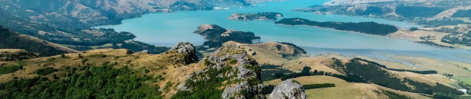
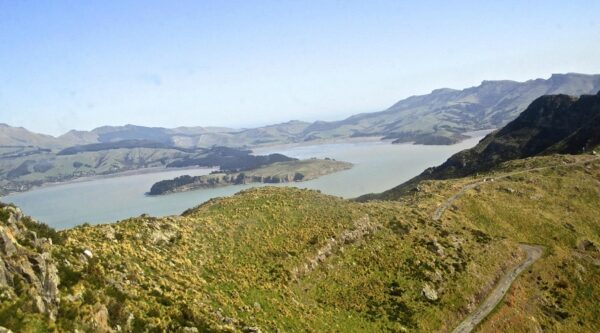
The Port Hills form the southern edge of Christchurch, running from Godley Head in the east through to Gebbies Pass in the west. They rise directly from the city and overlook Lyttelton Harbour, creating a long, accessible ridgeline rather than a single destination.
For many people, the Port Hills are not somewhere you go to - they are somewhere you enter, often briefly and often repeatedly.
–How people arrive
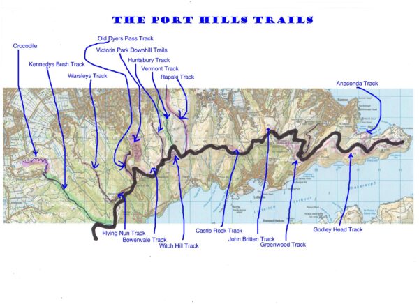
Access to the Port Hills is defined by edges rather than gateways:
- Road ends in suburban streets
- Small carparks at track entrances
- Summit Road pull-offs
- Walking and cycling links from the city
This makes the hills unusually democratic. You don’t need a full day, special gear, or a plan - many visits begin simply because time and weather allow it.
–What people do here
The Port Hills support a wide range of everyday recreation:
- Short and medium walks on formed tracks
- Cycling, from gentle rides to more demanding climbs
- Photography and sketching from viewpoints
- Bird watching, particularly along bush remnants
- Picnics and quiet stops along Summit Road
- Casual exploration of ridges, gullies, and tracks
Most visits are short. Many people come back again and again, using the same routes in different light, weather, and seasons.
–A place of layers
What makes the Port Hills distinctive is how layered they are:
- Urban on one side, rural and harbour-facing on the other
- Exposed ridges alongside sheltered gullies
- Open grassland next to regenerating bush
- High viewpoints within minutes of suburbia
You don’t have to go far to feel a change in character - often just one turn in a track is enough.
–Access and continuity
Recreation on the Port Hills depends heavily on:
- Continuous public tracks
- Clear connections between routes
- Open road margins and pull-offs
- Predictable access points
Because many routes link together, small closures or missing links can have outsize effects, breaking loops and limiting casual use. Continuity matters as much as scenery.
–Shared use in practice
The Port Hills are heavily shared:
- Walkers and runners
- Cyclists
- Families
- People stopping briefly for views
- Locals fitting recreation into daily life
Most shared use is managed informally, through familiarity and expectation rather than rules. Courtesy and predictability do most of the work.
–Who this place is for
The Port Hills work especially well for:
- City residents with limited time
- People easing back into activity
- Families and mixed-ability groups
- Older users who value formed tracks
- Anyone wanting outdoor space without travel
They show how close-to-home landscapes can support a surprising breadth of recreation when access is clear.
–Why the Port Hills matter
The Port Hills demonstrate something central to the Places series:
Outdoor recreation does not always depend on remoteness.
It often depends on proximity, continuity, and choice.
They are not a wilderness, and they don’t need to be. Their value lies in how often they are used, not how far away they feel.
–Editorial note
The Port Hills pair naturally with Activities such as:
- Walking (short & medium)
- Road cycling on formed routes
- Outdoor photography
- Picnics & quiet stops
- Sketching outdoors
They are a reminder that everyday landscapes, when accessible, carry much of a region’s recreational life.